LABORATORY: CNR ISPC
NAME OF THE INSTRUMENT
Global Navigation Satellite System (GNSS)
- Leica GS18T
- GeoMax Zenith60 LTE-UHF
- GeoMax Zenith60 LTE-UHF-IMU
GENERAL DESCRIPTION
The DGPS, or rather GNSS (Global Navigation Satellite System), is a measuring instrument ordinarily used in the topographic surveys to position points on the Earth’s surface, determining its coordinates.
GPS is a measurer of the vector components in a three-dimensional space (vector that connects two points on the Earth’s surface), from which it is possible to obtain its orientation and length. GPS is composed of a system of instruments (2 satellite receivers, one configured as a base and the other as a rover, and a controller) which provides a geo-spatial positioning service with global coverage, allowing to determine the geographic coordinates on any point on the Earth’s surface
MOLAB has different GNSS models:
Leica GS18T
GeoMax Zenith60 LTE-UHF
GeoMax Zenith60 LTE-UHF-IMU
TECHNICAL DESCRIPTION
GNSS (1)
Model name: 1 Leica GS18T
- Self-learning GNSS: Leica RTK plus = autonomous selection of satellites to adapt to any condition, SmartLink (correction service worldwide) = precise positioning in remote areas (3 cm 2D) from initial convergence to full accuracy in 20 - 40 minutes;
- SmartLink fill (correction service worldwide) = up to 10 minutes of RTK outage coverage (3 cm 2D)
Leica SmartCheck: continuous monitoring of the RTK solution, 99.99% reliability - Signal tracking: GPS (L1, L2, L2C, L5), Glonass (L1, L2, L32), BeiDou (B1, B2, B32), Galileo (E1, E5a, E5b, Alt-BOC, E62), QZSS (L1, L2, L5, LEX2), NavIC L53, SBAS (WAAS, EGNOS, MSAS, GAGAN), L-band
- Receiver accuracy and performance: RTK = horiz.: 8 mm + 1 ppm / vert.: 15 mm + 1 ppm; RTK Network = horiz.: 8 mm + 0.5 ppm / vert.: 15 mm + 0.5 ppm
- Controller and software: Leica Captivate, controller Leica CS20, tablet Leica CS35
- Data storage: flash memory= removable SD card (8 GB); data type and recording rate = raw data GNSS Leica and RINEX up to 20 Hz
- Power management: internal = rechargeable and removable Lithium-Ion batteries (2.8 Ah / 11.1 V); external = 12 V CC – range 10.5 – 28 V CC; operating time = 7 hours of data reception (Rx) with internal radio, 5 hours of data transmission (Tx) with internal radio, 6 hours of data reception/transmission with internal telephone modem.
Sistema GNSS (2)
Model name: 1 GeoMax Zenith60 LTE-UHF
- Receiver Reliability: 99.99%
- Receiver accuracy and performance: RTK = horiz.: 8 mm + 1 ppm / vert.: 15 mm + 1 ppm; RTK Network = horiz.: 8 mm + 0.5 ppm / vert.: 15 mm + 0.5 ppm reliability 99,99%
- Signal tracking: GPS (L1 C/A, L1C, L2C, L2P, L5), Glonass (L1 C/A, L2 C/A, L2P, L3), BeiDou (B1l, B1C, B2l, B2a, B2b, B3), Galileo (E1, E5a, E5b, AltBOC, E6), QZSS (L1 C/A, L1C, L2C, L5, L6), NavIC L53, SBAS (WAAS, EGNOS, MSAS, GAGAN), L-band
- Data storage: double; removable microSD card and internal memory 8 GB
- Power management: internal - two Lithium-Ion batteries = 3.4 Ah / 7.2 V; external - 9 V a 28 V, LEMO® connector; operating time: 12.5 h in static mode / 11 h in rover mode.
Referent:
Giuseppe Scardozzi giuseppe.scardozzi@cnr.it
Sistema GNSS (3)
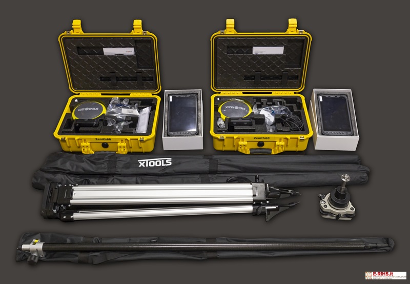
Model name: 2 Zenith60 LTE-UHF-IMU
- Kit of 2 GNSS systems with a multi-constellation set equipped with 555 channels and the possibility of base + rover configuration.
- Receiver Reliability: 99.99%
- Receiver Precision and Performance: RTK = horizontal: 8 mm + 1 ppm / vertical: 15 mm + 1 ppm; Long Static = horizontal: 3 mm + 0.1 ppm / vertical: 3.5 mm + 0.4 ppm, with 99.99% reliability.
- Signal Tracking: GPS (L1 C/A, L1C, L2C, L2P, L5), Glonass (L1 C/A, L2 C/A, L2P, L3), BeiDou (B1l, B1C, B2l, B2a, B2b, B3), Galileo (E1, E5a, E5b, AltBOC, E6), QZSS (L1 C/A, L1C, L2C, L5, L6), NavIC L53, SBAS (WAAS, EGNOS, MSAS, GAGAN).
- Data storage: double; removable microSD card and internal memory 8 GB
- IMU (Inertial Measurement Unit): Special sensor for calculating points at the tip of the stake when it is inclined up to 60°.
Accessories:
- 2 eSurvey UT32 Android Tablets for GPS
- 1 Aluminum tripod with trivet
- 2 X-PAD Ultimate survey GNSS software
- 2 Prism poles with a length of 2.5 m
- 1 Trivet with prism/GPS adapter
- 2 X-Pad Office X-TOPO
Referents:
Daniele Ferdani: daniele.ferdani@cnr.it
Andrea Angelini: andrea.angelini@cnr.it
