SERVICE NAME
Searching, processing and archaeological interpretation of archived aerial photos, space photos and optical satellite imagery
GENERAL DESCRIPTION
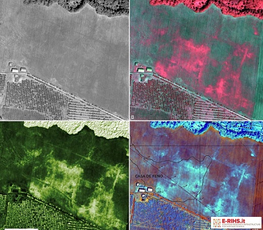
The MOLAB offers a service concerning the research, acquisition, processing and archaeological photointerpretation of aerial and satellite remote sensing data available in archives and relating to any site under study. These data represent an incredible container of direct information and a useful tool for identifying marks and anomalies that reveal the presence of not visible archaeological or paleo-environmental elements or features difficult to detect by only on-field survey; moreover, historical data can allow the identification of archaeological remains, which are no longer visible today or poorly preserved due to the rapid territorial transformations that have changed the original appearance of the historical landscape.
These are the archival remote sensing data that can be searched, processed and interpreted for archaeological purposes: historical aerial photos (1930-1990); space photos from the 1960s and 1970s (KH-4A and KH-4B Corona images, KH-7 Gambit and KH-9 Hexagon images); high-resolution optical satellite images acquired by the platforms in orbit from 1999, which provide multispectral and panchromatic data with a maximum resolution up to 30 cm. The satellite images can also be processed by applying the most recent remote sensing methodologies for archaeology and using specific software. In particular, various enhancement techniques may be applied on images, enhancement allowing to emphasize anomalies and archaeological traces related to buried ancient structures, or paleo-environmental elements, such as soil-, crop-, dump- and shadow-marks.
The service offered by MOLAB also includes the field checks and georeferencing of traces and anomalies detected by the archaeological photointerpretation.
TECHNICAL DESCRIPTION
Dataset
Historical aerial photos:black and white or colour images, with glass plates negatives or film negatives
Historical cosmic photos:
- Corona KH-4A and KH-4B Missions (geometric resolution: 1.8-2.7 m)
- Gambit KH-9 Missions (geometric resolution: 0.6-1.2 m)
- Hexagon KH-9 Missions (geometric resolution: 0.6-1.2 m)
Very high-resolution optical satellite images (e.g., Ikonos-2, QuickBird-2, GeoEye-1, WorldView-2, WorldView-3, WorldView-4, Pléiades1A/1B, Pléiades Neo data, etc.)
Referent:
Giuseppe Scardozzi giuseppe.scardozzi@cnr.it
