LABORATORY: CNR ISPC
NAME OF THE INSTRUMENT
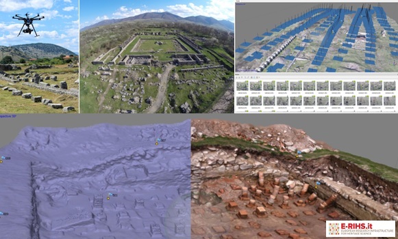
Unmanned Aircraft Systems (UAS) equipped with a radio-controlled gimbal capable of mounting any photographic or video recording instrument up to a maximum load of 5kg; Full-Frame cameras equipped with various fixed optics.
GENERAL DESCRIPTION
The CNR ISPC laboratories have a strong know-how in survey methodologies and techniques integrating image-based e range-based solutions aimed at surveying Cultural Heritage, documentation, and scientific visualization. The laboratories are equipped with instrumentation and active and passive sensors for the 2D and 3D digitization of monuments and archaeological sites. The institute's instrumentation mainly consists of terrestrial and aerial photogrammetric systems (high-resolution photographic cameras and several lenses, UAS), laser scanning systems (TOF and phase-based), topographic systems such as the differential GPS, for the positioning of points on the territory, intended both as points of fixed stations for the constitution of polygonal, and points for the determination of the shape of the territory, which can be loaded directly on the most common GIS platforms (QGIS), and total station. In the context of a 3D survey project, CNR ISPC can offer its scientific collaboration for the planning, survey, processing, interpretation, and visualization of the surveyed data.
CNR ISPC can perform both terrestrial and aerial survey operations using Remotely Piloted Systems (SAPR), more commonly known as drones.
TECHNICAL DESCRIPTION
Photogrammetry is the science of extracting metric information from photographs. Recently, thanks to technological innovation and the use of Computer Vision, automated photogrammetric techniques have been developed. These techniques allow the elaboration of 3D models, starting from a very dense sampling of two-dimensional images, using automated procedures, to be performed. CNR-ISPC uses various image-based techniques to process 3D models:
● Multi stereo view reconstruction: this is a photogrammetric technique of automatic processing. In addition to the traditional photogrammetric principles, this technique also takes advantage of algorithms structure from motion e dense stereo reconstruction that make it possible to analyse and correlate photographs automatically and extract coloured point clouds.
● Spherical photogrammetry: Thanks to the evolution of surveying techniques and in particular spherical photogrammetry, it is now possible to use panoramic images or photos (360° spherical images) not only for “traditional” monoscopic VR navigation (such as QTVR) but it is also possible to georeference the images, extract 3D geometries and, above all, project high-resolution textures onto the 3D models surfaces. The technique guarantees high accuracy and completeness of the data. It is also possible to integrate the results with data from other surveying techniques such as laser scanning. Spherical photogrammetry is well suited to support the creation of immersive contents and their use within interactive navigation systems based on HMD (Head Mounted Display), devices. An example of an advanced immersive system is the DPF (Depth Panoramic Frame)Depth Panoramic Frame, a technology that allows a stereoscopic vision of the reconstructed scene using only two images - or videos - with spherical projection: one with colour information (diffuse map) and one with depth information (depth map).
Referents:
Daniele Ferdani daniele.ferdani@cnr.it
Andrea Angelini andrea.angelini@cnr.it
